HOUSTON-If you think history is boring, J.P. Bryan is about to prove otherwise.
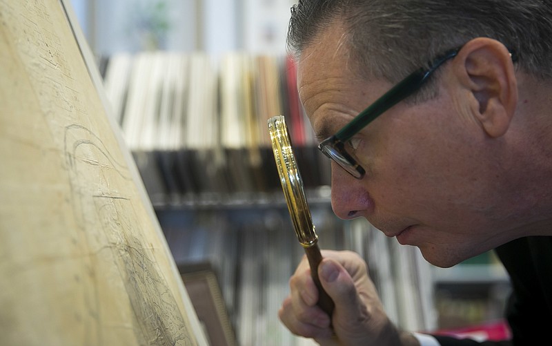
The Houston oilman and avid historian opened his Bryan Museum in Galveston in 2015 to house his vast collection of Texana, and his newest acquisition, the only remaining Original Borden Map of the City of Houston, comes with stories full of celebrity, intrigue and deception-and there's a brothel mixed in, too. Houston's founders used the Borden map, the oldest known plan of the city, to illustrate for sale the size and location of the lots, blocks and streets of the proposed municipality.
"I had been a history major, and I loved it, but most children find history boring," Bryan said of his experience talking to children who have visited his office and museum. "Goodness gracious, it's anything but boring. It's high adventure."
Now the map, once owned by Sam Houston himself, is being given to his museum by its longtime owner, Old Republic Title. The Bryan family officially received the document Thursday night at The Antiquarian, a Houston gallery of historic maps, artwork and documents. A protective container will be created and then the map will go on display in The Bryan Museum in a month or so.
The map, measuring 18 inches by 29 inches, was created in 1836 by mapmakers Gail Borden and Moses Lapham for city founders J.K. and A.C. Allen, brothers from New York who had come to Texas as land speculators. After the Texas Revolution, they sited their fledgling city at the confluence of the White and Buffalo bayous, the spot where steamboats could travel and turn around.
Borden and Lapham took their map to New Orleans and had 20 lithograph copies made. There's an inset of an early Stephen F. Austin map of the state and boxes of text that tout the city's virtues, since the Allen brothers used them to sell property to Easterners wanting to move West.
On the map, their sales pitch describes Houston as "beautifully elevated" and mentions rich soil, excellent spring water and fresh sea breezes. Naturally, there's no mention of our swampy elevation or our voracious mosquitoes.
"This is the gem of all of the maps," Bryan told the Houston Chronicle. "If you're a Californian and you had the original map of Los Angeles, you might argue you've got something of equal importance. For Texans and people in Houston, there's nothing to compare to it."
The Allen brothers gave one of their 62 blocks to Sam Houston and handed him this map as well. Houston kept a lot for his own offices and quickly sold other lots to various merchants, including one who operated Kessler's Round Tent Saloon (then known as a "grocerie") and another to Pamelia Mann, who had paid $500 to Harris County for a license to operate a brothel.
Incidentally, Mann's brothel was located in the center of the block facing the "Congress Square" block that for a short time housed the Republic of Texas' government.
Ed Grusnis, owner of The Antiquarian and caretaker of the map, said that Houston hung the map in his office for years and handed it down to his son, A.J. After A.J.'s death, the map was auctioned and Old Republic's predecessor-Houston Title Guarantee-bought it.
The map sat unnoticed in storage somewhere at the title company until scandal struck.
A newspaper story detailed a lawsuit filed by a man who believed that he'd been swindled by a map dealer. He'd sold his antique city of Houston map for a measly $8,000 and was angry that the dealer turned around and announced it for sale for $95,000.
Folks at the now-Old Republic title company saw the story and were curious. They had a map just like it. Or they thought they did, anyway.
Turns out the man selling the map was a disgruntled Old Republic employee who stole it on his last day of work. They approached the dealer and got the map back. The theft prompted them to find a safer place for this valuable document.
"It's surprising to me that they thought a map dealer was the safe place. My whole reason for being is to sell maps," Grusnis said, laughing. But Old Republic trusted Grusnis not only to care for the map, but also to help them find a suitable permanent home.
"We had an unsolicited offer for the map in the high six figures, but Old Republic had no interest in selling it. They thought, wisely, this is part of the heritage of Texas," Grusnis said.
That's where J.P. Bryan comes in. His passion for history has its own provenance. His great-great-grandmother Emily Austin Bryan Perry was a sister of Stephen F. Austin.
His father, James Perry Bryan Sr., was also a collector who in 1966 sold his own vast collection of Texas maps, documents and artifacts to the University of Texas.
When he did, J.P. Bryan realized that if he was ever going to have his own collection, he'd have to buy it himself. His first purchase was a pistol that he bought when he was 10 years old, using money he'd earned cutting grass.
"My dad was a lawyer for Dow Chemical, and occasionally he'd take me to things when I didn't need to be in school," he said. "We would go to this antique gun dealer, and I was fascinated with them. I bored the guy to death because I had no money, and I asked all kinds of questions."
As he made more money he collected more things-art, maps, artifacts and documents-and kept them in his Houston home. When the collection finally conflicted with his wife's taste in French decor and antiques, Mary Jon Bryan gave him an ultimatum: It's me or the maps.
He kept her and took the maps and other items to his offices where he hung them first in public spaces. As the collection continued to grow they found their way in individual offices, and he thought it would be a good idea to let school children come to see his things. He even hired his own docents to lead the tours.
Ultimately, his collection outgrew his offices, and his search for a suitable museum space lead him to Galveston and the former Galveston Orphans Home on 21st street. After a restoration, its 20,000 square feet were filled with some 70,000 items, including books, saddles, antique firearms, spurs, art and, of course, maps.
"When you have an addiction of collecting, it's a rather selfish endeavor because you're satisfying your own interests. Then when you have a chance to share it through a museum, it's vastly more rewarding," he said. "This is the foundational map of the city of Houston, which eventually will be the largest city in the west. It's just a wonderful claim to be able to make."


