
Someday Millwood State Park will be repaired, recovered, rebuilt and reopened if it doesn't flood again.
The four floods and a drought have changed the flow of wildlife in the state park located about nine miles east of Ashdown, Ark., next to the Millwood dam, said Millwood State Park Superintendent Mark Myers.
When the floods occurred in warmer weather in the late spring and summer, alligators swam near the park superintendent's house.
With the fourth flood occurring in December and somewhat cooler water, the alligators have found warm shelter.
But now coots and ducks swim near the house with less fear of predators.
This is preferable to the alligators migrating toward the house during the spring and summer floods, Myers said.
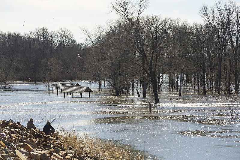
The state park has been mostly closed since May 12 because of flooding.
"It's been open basically a week or two here and there. Sometimes the boat ramps would be open and then it would flood again and we would have to close them again. We cannot catch a break," Myers said.
"We're prepared for floods. We've got it down," he said.
The marina and campground, the pavilion and the three bathroom facilities are under water. The bathrooms and the pavilion will have to be demolished.
"The buildings will be redone and the new buildings will be able to withstand flood waters," Myers said.
The new bathhouses will provide more privacy and the stalls will be similar to a family room. "It will be better for kids and more privacy," Myers said.
The facilities will cost about $137,000 each.
"The bathrooms will be built and delivered and then they can be set in place," Myers said.
"After the water recedes, then the damage can be discovered," he said.
The flood during the last week of December was just as bad as the floods in the spring and summer.
The buildings aren't the only things in the park to be damaged by the flood.
"The trees are taking a beating. The water went up 24 feet and then a drought occurred. Then it went back to flooding. The pine trees are under stress because of the water and pine beetles. The oak trees are stressed and it will be later this spring before we can see if they come back. The hickory trees have been wiped out," Myers said.
Myers tries to be positive saying when the park is rebuilt, it will be better.
The roads should be improved, along with the bathhouses, and playgrounds.
The flood waters have also made it easier to fish.
"We've been able to fish in the front yard. I'm trying to make lemonade out of lemons," he said.
Myers has plenty of Millwood water to make the lemonade.
n n n
"When it rains, it floods. I would not have believed Broken Bow Lake would rise 15 feet, but that's Oklahoma," said Brannen Parrish, public information specialist with the Army Corps of Engineers, Tulsa District, in a previous Gazette story.
The water from Broken Bow flows into the Mountain Fork and Little rivers. Little River leaves McCurtain County, Okla., and flows along the border of Little River and Sevier counties in Southwest Arkansas.
The Little River then flows into Millwood Lake, which helps feed the Red River.
Millwood Lake set a new record with a lake level of 282.41 feet at 4:30 p.m. June 12 and set another new mark at 283.3 feet June 13.
The previous record was 282 feet, recorded May 23, 1968, said Aaron Short, hydraulic engineer for the Army Corps of Engineers Little Rock District.
The purpose of the lake is a key unit in the general flood-reduction system for the Red River below Lake Texoma. This operates in conjunction with Texoma and Pat Mayse, Hugo, Pine Creek, Broken Bow, De Queen, Gillham and Dierks lakes in the Little River basin.
The project was authorized by the Flood Control Act of 1946 and modified by the Flood Control Act of 1958. It was designed by and built under the supervision of the Corps of Engineers' Tulsa District. Construction of the dam began in 1961 and was completed for flood-control operations in 1966 at a cost of $44 million. It was dedicated Dec. 8, 1966.