
WACO, Texas-To get to New Zion Cemetery, you drive down a grass-covered lane as far as you can, get out and walk, and hang a left at the longhorn cow.
The Waco Tribune-Herald reports at the end is a thicket of oak and pecan trees.
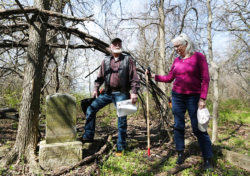
And if you push aside the spring growth of vinca, greenbrier vines and flowering plum, you can see the names of a forgotten black community, etched in concrete or marble. There's Capt. A.J. Sanders, 1892-1928, his tombstone surrounded by a sinking concrete curb. Nearby is a Korean War veteran, Sgt. James Nelson Jr., 1931-1967. Dozens more poke out among the vines or lie on their sides.
The cemetery off South Third Street in Downsville is unmarked and unfenced, but it is no longer unmapped, thanks to the tireless labors of a few local history buffs.
Sharon McNary, Rita Ballentine Hogan and John Kamenec have spent the last two years visiting every bramble-covered cemetery of McLennan County and visiting local funeral homes to create a comprehensive cemetery map.
The map, created with help from the McLennan County mapping office, pinpoints some 240 cemetery locations across the county, about two-thirds of which have never appeared on a map, McNary said. McNary has also written descriptions of each cemetery, recorded GPS coordinates, and provided to the material to the West Waco Library's Genealogy Center.
Center supervisor Bill Buckner said the volunteer effort is a big leap forward for genealogy and local history in Waco.
"I've been here for 19-plus years, and I've been working with a cemetery interest group during that time," Buckner said. "This is truly monumental. We have been trying to get to this level of having this information well organized and well documented. These three got it done."
McNary said she hopes the map will help descendants track down the history behind the county's forgotten markers. Those descendants are often out of town, a fact she kept in mind in writing the book that accompanies the map, McNary said.
"If a family member lived out of state and wanted to know about a cemetery, I tried to describe it through my eyes," she said. "I could say we drove up, and it had a beautiful iron gate, the taller headstones are on the right side, there's a flagpole. I think that's really meaningful for the family."
Cemeteries on the map range from individual family plots on private ranchland to giant public cemeteries such as Oakwood and First Street. Some have vanished without a trace, such as the Lovers Leap Cemetery near Cameron Park. There are numerous African-American cemeteries, a few Hispanic cemeteries and even an "Indian burial ground" near the semi-neglected Cox Cemetery near Bruceville-Eddy.
Some cemeteries are not only defunct but underwater, at least at times: Massie, Greenwood West and McLennan Cemeteries were flooded with the creation of modern Lake Waco in the mid-1960s.
Many others are neglected but still recognizable as cemeteries. McNary said she suspects the process of mapping the cemeteries with the permission of landowners will bring some needed attention to the sites. She said one landowner was a little embarrassed by the condition of the cemetery he owned and suggested that it might be cleaned up by the end of this year.
"We've had quite a few headstones in cow pastures with cows running around them," McNary said. "We're afraid that in the future they're going to get broken."
Under Texas law, landowners must ensure "reasonable access" to anyone wanting to visit a cemetery on or surrounded by private land. Landowners may establish access routes and visiting hours to cemeteries.
The new county cemetery map shows a high concentration of about a dozen African-American cemeteries in the Brazos River Valley southeast of Waco. The area around Downsville, Harrison and Asa was home of numerous cotton plantations before the Civil War and freedman communities starting with Reconstruction.
The New Zion Cemetery at Downsville was once part of a black community and had a schoolhouse next to it, said Kamenec, a retired surveyor, but little is known about it. Using old maps, he located the foundation stones of the old school.
The gravestones appeared to be mostly from the early 20th century, though some are more recent, including one for Elisha Johnson, 1910-1972. Some headstones are made of concrete or recycled materials such as a millstone or a masonry roof cornice. But some would be considered elaborate even by today's standard, including the carved marble headstone for Mary Morgan, who lived from 1897 to 1918.
On a recent visit to the cemetery, Kamenec and Hogan said there are likely many headstones that are lost to history.
"It's so frustrating for people who care about history to know there must be tombstones just that far underground," Hogan said. "But we don't have permission to go excavating."