
Can't see the video? Click here >> https://www.youtube.com/watch?v=aQb9GO5PKmI
NORTH MYRTLE BEACH, S.C. - Coastal residents secured patio furniture, ferry operators completed evacuations on the Outer Banks, and officials passed out sandbags and offered car space in elevated garages Monday as Isaias marched northward, forecast to hit the Carolinas as a minimal hurricane.
The U.S. National Hurricane Center warned oceanside home dwellers to brace for storm surge up to 5 feet (1.5 meters) and up to 8 inches (20 centimeters) of rain in spots, as Isaias moves up the coast. The Carolinas weren't the only states at risk.
"All those rains could produce flash flooding across portions of the eastern Carolinas and mid-Atlantic, and even in the northeast U.S.," said Daniel Brown, senior hurricane specialist at the U.S. National Hurricane Center. A tropical storm warning extended all the way up to Maine, where flash flooding was possible in some areas on Wednesday.
Isaias (pronounced ees-ah-EE-ahs) killed two people in the Caribbean and roughed up the Bahamas but remained at sea as it brushed past Florida over the weekend, providing some welcome relief to emergency managers who had to accommodate mask-wearing evacuees in storm shelters. The center of Isaias remained well offshore as it passed Georgia's coast on Monday.
President Donald Trump on Monday described Isaias as "very serious."
"Storm surge and inland flooding are possible and everyone needs to remain vigilant until it passes," Trump said.
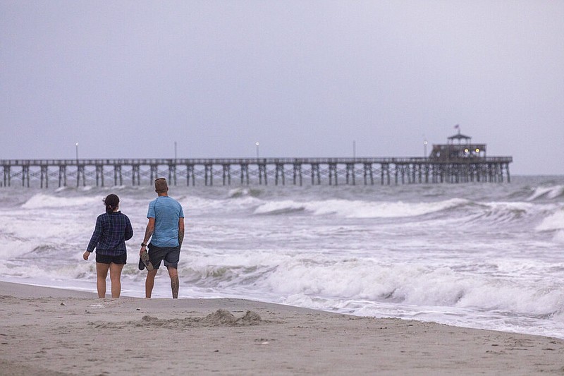
Authorities in Myrtle Beach, South Carolina, ordered swimmers out of the water to avoid rough surf and strong rip currents. Still, many people were out enjoying the beach and walking their dogs under overcast skies.
On Pawleys Island, southwest of Myrtle Beach, Terrie Wilson Heffner moved outdoor furniture and potted plants and kept her TV tuned to weather reports. A coastal South Carolina resident since 1981, when Hurricane Hugo destroyed her parents' home, Heffner said she doesn't leave except for major storms.
"They don't really scare me," Heffner said, "but I have great respect for them."
Shops and restaurants appeared quieter than usual for a summertime Monday in North Myrtle Beach, but locals blamed COVID-19 more than Isaias. No businesses were boarding up their windows, although some moved outside furniture inside.

Wayne Stanley and his family came to the city over the weekend from Julian, North Carolina. He's never experienced a hurricane, but said he never considered canceling his family's weeklong vacation either.
"I was pretty scared to start off with," Stanley said Monday. "Then we thought maybe it's not going to be that bad."
Officials in frequently flooded Charleston, South Carolina, handed out sandbags and opened parking garages so residents on the low-lying peninsula could stow their cars above ground.
Though the center of Isaias was expected to pass offshore of Charleston on Monday evening, National Weather Service meteorologists said a major flood is possible if rainfall is heavy when the high tide arrives about 9 p.m. The hurricane center predicted storm surges of 3 to 5 feet (0.9 to 1.5 meters) in portions of both North and South Carolina.
Charleston Mayor John Tecklenburg told a news conference he didn't plan a curfew, though city offices were closing early. He asked residents to stay home after 6 p.m. when winds are predicted to increase above 40 mph (64 kph) and flooding could be at its worst.
"It's a great night, as long as your power is up, to watch a movie or read a book," Tecklenburg said. "Just chill out this evening. Stay home and stay safe."
North Carolina Gov. Roy Cooper warned residents on Monday that the storm could be dangerous regardless of its strength. He urged those evacuating to turn to shelters as a last resort, citing coronavirus risks and the need to operate shelters at reduced capacity to allow for social distancing.
"Whether it's labeled a tropical storm or a hurricane, you should take this storm seriously, and make sure your family is ready," Cooper said.
Ferry operators wrapped up evacuations from Ocracoke Island in North Carolina's Outer Banks on Monday, moving more than 3,500 people and 1,700 vehicles off the island over four days. Island officials were taking no chances after taking a beating less than a year ago from Hurricane Dorian. Evacuation orders also have been issued for Hatteras Island north of Ocracoke.
Morgan Stewart said many evacuating residents had come into the store where she works in the inland community of Kinston to buy tarps, batteries, flashlights and other supplies.
"You can tell they're worried," said Stewart, who saw cars parked on higher ground over the weekend as she secured her boat at a marina.
Isaias was still a tropical storm at 5 p.m. EDT with maximum sustained winds of 70 mph (110 kph), but it was expected to strengthen into a Category 1 hurricane later Monday, with winds of 74 mph (119 kph) or more. The storm was centered about 120 miles (193 kilometers) southwest of Myrtle Beach on Monday afternoon.
Since forming last week, Isaias has been buffeted by competing forces both trying to kill and strengthen it, said University of Miami hurricane researcher Brian McNoldy.
"Of all the places it could be, it found the warmest water it could," which fuels storm development, McNoldy said. "And yet it is struggling."
That's because dry air kept working its way into the storm at low and mid-levels, which chokes storms.
Isaiah's passage near Florida over the weekend was particularly unwelcome to authorities already dealing with surging coronavirus caseloads. The storm brought heavy rain and flooding to the state, forcing authorities to close outdoor virus testing sights, as well as beaches and parks. Officials lashed signs to palm trees so they wouldn't blow away.
About 150 people had to keep masks on while sheltering in Palm Beach County, which had a voluntary evacuation order for people living in homes that can't withstand dangerous winds, said emergency management spokeswoman Lisa De La Rionda.
Isaias was blamed for two deaths in the Dominican Republic and Puerto Rico, where it uprooted trees, destroyed crops and homes and caused widespread flooding and small landslides over the weekend. The storm snapped trees and knocked out power Saturday in the Bahamas. Shelters were opened on Abaco island to help people still living in temporary structures since Dorian devastated the area, killing at least 70 people in September 2019.