
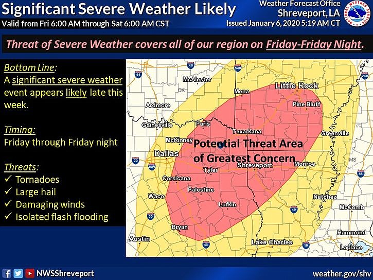
TEXARKANA - The chance of severe storms in Texarkana and the surrounding area today has been upgraded to a moderate risk, according to the National Weather Service in Shreveport, La.
"This is looking to be a widespread event and every part of our area is under the gun. This line is going to push through our entire area,"said Matt Hemingway, meteorologist with the NWS.
"This is only the fourth moderate risk issued in January since 2003. A moderate risk brings the possibility of EF 2 or EF 3 tornadoes. You need to make a plan for if things get dangerous and know what you are going to do," Hemingway said.
The timing for storms in Texarkana will be between 9 p.m. and midnight Friday, but timing can always be uncertain, Hemingway said.
"As far as threat levels go, we are in the moderate area. These storms could be very persistent and widespread," Hemingway said.
The NWS describes the category of moderate storms as "long-lived, widespread and intense." These storms are capable of producing winds between 60 to 80 mph.
Meteorologists recommend people have several ways to receive weather warnings throughout Friday night.
Strong winds will be the primary concern with this system, but the secondary concern will be heavy rainfall, Hemingway said.
Areas north of Interstate 30 could see between 3 to 4 inches of rain and flash flood watches are expected to be issued. Flash flooding can easily produce 1 to 2 inches of rain in a very short time, Hemingway said.
The storms should move east of the area by Saturday morning.
Hemingway said storms that hit at night can always pose dangerous risks.
"You can't see anything, so don't try to go outside and look at it. Heed all warnings that are issued and if there is one for your area, take shelter. Have a plan in place and know where to go. Go in an interior room, closet or bathroom and take pillows and blankets or anything you can put over your head in case of debris," he said. "The more things you have to protect you, the better."
Even if there is no tornado, trees and power lines can easily be toppled by straight line winds.
"These are winds that can really pose a threat," he said.
The NWS recommends everyone have multiple ways to get information, including NOAA weather radio or cell phone alerts such as Code Red.
Hemingway also urges people to check on their friends and family and make sure they are weather aware.
"You may be weather savvy, but they may not be," he said.
A tornado watch means conditions are favorable for tornadoes. A tornado warning is issued when possible rotation is seen on the radar.
"As events start to happen and storms appear on radar, that's when warnings are issued and you need to take cover," Hemingway said.
Employees of Southwestern Electric Power Co. (SWEPCO) are ready to respond in the event of power outages.
Through its network of mutual aid, SWEPCO has 150 utility workers from Ft. Worth, Abilene and Austin, Texas to assist with power restoration, according to a news release.
SWEPCO advises to always assume that any downed utility line is energized and stay away. Report downed lines immediately to SWEPCO at 1-888-218-3919.